


2018 School Spending Survey Report
Mapping Sam by Joyce Hesselberth | SLJ Review
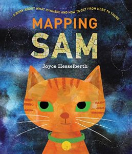
PreS-Gr 3 –Once Sam the cat makes sure her family is asleep, she sets out to explore the neighborhood.
![]() HESSELBERTH, Joyce. Mapping Sam. illus. by Joyce Hesselberth. 40p. HarperCollins/Greenwillow. Oct. 2018. Tr $17.99. ISBN 9780062741226. POP
HESSELBERTH, Joyce. Mapping Sam. illus. by Joyce Hesselberth. 40p. HarperCollins/Greenwillow. Oct. 2018. Tr $17.99. ISBN 9780062741226. POP
PreS-Gr 3 –Once Sam the cat makes sure her family is asleep, she sets out to explore the neighborhood. Hesselberth uses this conceit to build a playful yet informative narrative based around cartography. First readers explore an neighborhood map of the feline’s initial travels before embarking on a journey that will take them to the edge of the universe and back. Hesselberth’s maps range widely, from diagrams of Sam’s anatomy, a plant, and a water molecule to charts of planets and stars to architectural drawings. Some common cartography terms like compass rose and legend are defined. The spare text emphasizes ways readers can find patterns and relationships in their surroundings and the artwork—done in watercolor, acrylic paint, gouache, and digital collage—presents this information visually. Hesselberth’s Sam is perfectly catlike as her expressions shift among bemusement, curiosity, and sass. Additional context about each type of map is provided at the end of the book. These thumbnails will prove useful for older readers or adults working with beginners. Librarians will also want to seek out Julie Dillemuth’s Mapping My Day and Loreen Leedy’s Mapping Penny’s World to extend conversations on this subject. VERDICT An eye-catching introduction to maps, charts, and diagrams for the youngest of cartographers.
This review was published in the School Library Journal June 2018 issue.

Added To Cart
RELATED
BOOKS
PREMIUM
Tide’s Journey
BOOKS
PREMIUM
The Smushkins: ABC Zoinks
BOOKS
PREMIUM
Whose Footprint Is That?
BOOKS
PREMIUM
Our World: Vietnam


RECOMMENDED
CAREERS
The job outlook in 2030: Librarians will be in demand
CAREERS
The job outlook in 2030: Librarians will be in demand
ALREADY A SUBSCRIBER? LOG IN
We are currently offering this content for free. Sign up now to activate your personal profile, where you can save articles for future viewing
ALREADY A SUBSCRIBER? LOG IN
Thank you for visiting.
We’ve noticed you are using a private browser. To continue, please log in or create an account.

Add Comment :-
Be the first reader to comment.
Comment Policy:
Comment should not be empty !!!